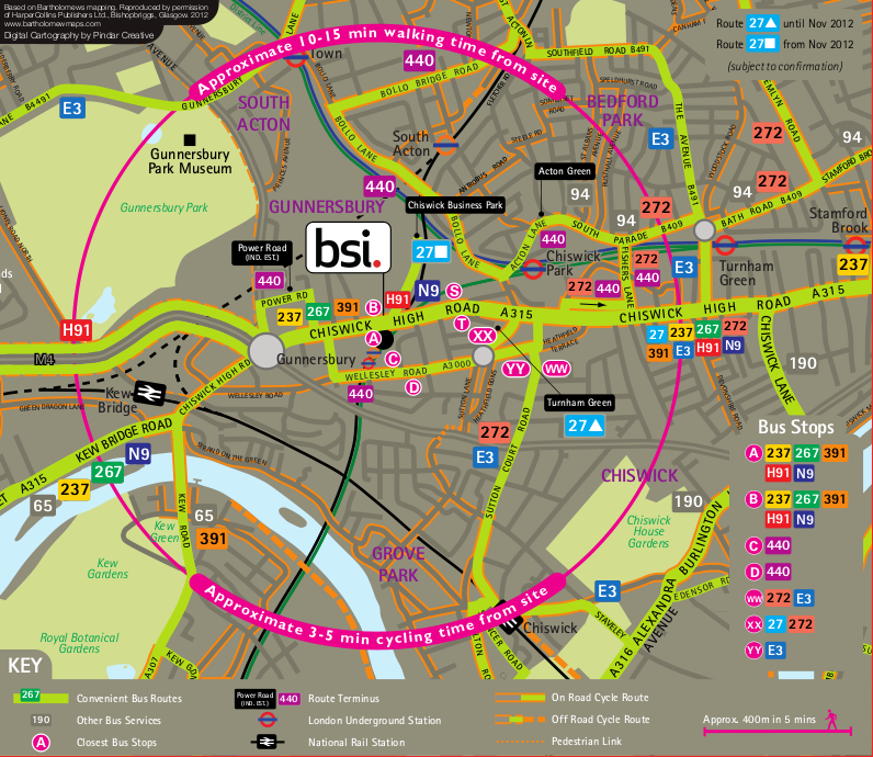
Journey Planner
by Bus
27, 237, 267, 272, 391, 440, E3, H91, N9 all detailed on the map above.
by Foot
Around a 10-15 minute walk from the sit map above, shown in the coloured circle. A free walking journey planner is available at www.walkit.com which can help you plan your route.
by Bicycle
Cycle Maps covering the whole of London are available from TFL - see www.tfl.gov.uk/cycling The bicycle parking area is on the middle deck of the BSI car park. Please obtain a code to the bicycle cage lock from security on 02089967304 or by email at security@bsi.group.com
by Motor Vehicle
If using the M3, M4 and M40 - Take the relevant route to Chiswick Roundabout, then the relevant exit onto the A315 (Chiswick High Road), take the second road on the right into Oxford Road North, then turn left onto Wellesley Road. Please book a parking space on 02089967304 or via the email.
by Train
• The London Overground runs between Richmond and Stratford stopping at Gunnersbury. • The 'Hounslow Loop' has stations at Kew Bridge, Richmond, Weybridge, Brentford, Syon Lane and Hounslow.
by Tube
The nearest accessible stations to Gunnersbury Station: • District and Picadilly lines - Acton Town • District line and London Overground - Kew Gardens (Bus route 391 goes to Gunnersbury station) • Picadilly line - Hammersmith (BUs routes H91 and N9 go to Gunnersbury station)
by Cab
For a cab got to either www.tfl.gov.uk/modalpages/2680.aspx or ukcabnumbers.com or www.greetomatocars.com